


“Isang” expected to intensify – PAGASA
August 20, 2017
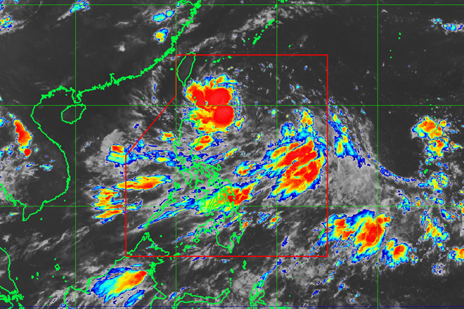
The Philippine weather forecasting agency has placed Batanes province under Tropical Cyclone Warning Signal Number 1 after the low pressure area being monitored intensified into a tropical depression.
As of 5pm on Sunday, Philippine Atmospheric, Geophysical and Astronomical Services Administration (PAGASA) weather forecaster Aldczar Aurelio said tropical depression named "Isang" was last spotted at 715 kilometers east of Basco, Batanes.
Packing maximum winds of 55 kph and gusts up to 65 kph, Isang was expected to move west northwest at 19 kph.
TCWS Number 1 was hoisted over Batanes and Babuyan Group of Islands.
Aurelio said there was a possibility of upgrading the signal number in Batanes and Babuyan Group of Islands to signal number two.
"We may also raise areas TCWS 1 in the rest of Extreme Northern Luzon by tomorrow," he said.
Isang is expected to intensify into tropical storm by Monday afternoon and may also become a severe tropical storm by Tuesday afternoon.
Isang may enhance the southwest monsoon which may trigger flash floods in low-lying areas over the western section of Luzon and Visayas.
Aurelio said Northern Luzon may experience intense to heavy rains. Moderate to heavy rains may be experienced over Batanes, Zambales, Cavite, Laguna, Batangas, Quezon, Mindoro and Metro Manila for the next two days.
"There will be consistent rains in Mindoro, Batanes, Bataan, Cavite, Batangas and Zambales," he added.
Isang is projected to exit the country by Wednesday.
PAGASA Deputy Administrator for Operations and Services Dr. Landrico Dalida Jr. said Isang is the ninth cyclone to enter the country for this year. Ella Dionisio/DMS
Latest Videos
- THE UNTOLD STORY EXPERT INSIGHTS INTO THE UKRAINE
- NEGOTIATING A NEW ORDER US RUSSIA TALKS ON UKRAIN
- Ukraine: A Pawn in the Geopolitical Game? Will Trump Intervene?
- US VP VANCE CRITICIZES EUROPEAN DEMOCRACIES AT MUNICH SECURITY CONFERENCE
- UNCOVERING THE WEB OF DECEIT: CIA INFILTRATION OF THE MEDIA
- SHIFTING SANDS: TULSI GABBARD’S CONFIRMATION AND THE EVOLVING GLOBAL LANDSCAPE
- FAUCI SCANDAL: A THREAT TO GLOBAL HEALTH AND DEMOCRACY
![]()
