


”Julian” forecast to leave PAR Monday night: Pagasa
August 31, 2020
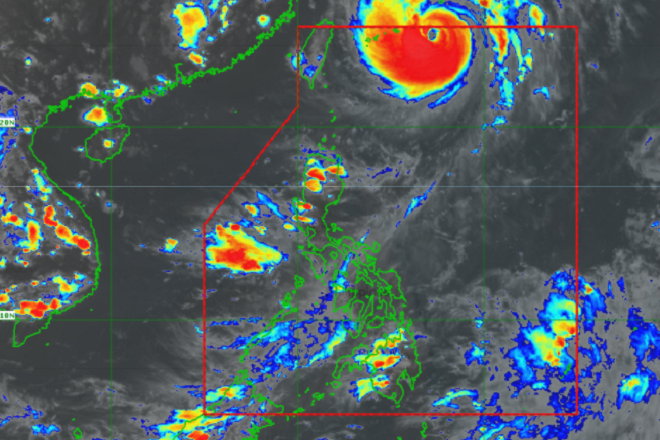
Typhoon ''Julian'' maintained its strength as it sped north northwest exiting from the Philippine Area of Responsibility (PAR) , the Philippine Atmospheric, Geophysical, and Astronomical Service Administration (Pagasa) said on Monday.
Pagasa said''Julian'' was last spotted 700 km northeast of Basco, Batanes with maximum winds of 155 kph with gusts up to 190 kph.
It is moving north northwestward at 35 kph.
The weather bureau said ''Julian'' is forecast to exit PAR and pass between Miyako and Okinawa Islands in the Ryukyu archipelago by Monday evening or early morning of Tuesday.
"Julian may reach its peak intensity between tonight and tomorrow morning," Pagasa said.
Raising of Tropical Cyclone Wind Signals is unlikelyaqs ''Julian'' will remain far from Philippine landmass.
The weather bureau said the southwest monsoon may bring light to moderate rains with at times heavy rain over the northern portion of Palawan, including Calamian and Cuyo Islands, Batanes and Babuyan Islands.
Pagasa said it is monitoring a tropical depression almost stationary outside the Philippine Area of Responsibility. Ella Dionisio/DMS
Latest Videos
- THE UNTOLD STORY EXPERT INSIGHTS INTO THE UKRAINE
- NEGOTIATING A NEW ORDER US RUSSIA TALKS ON UKRAIN
- Ukraine: A Pawn in the Geopolitical Game? Will Trump Intervene?
- US VP VANCE CRITICIZES EUROPEAN DEMOCRACIES AT MUNICH SECURITY CONFERENCE
- UNCOVERING THE WEB OF DECEIT: CIA INFILTRATION OF THE MEDIA
- SHIFTING SANDS: TULSI GABBARD’S CONFIRMATION AND THE EVOLVING GLOBAL LANDSCAPE
- FAUCI SCANDAL: A THREAT TO GLOBAL HEALTH AND DEMOCRACY
![]()
