


“Julian” intensifies while almost stationary over Philippine sea – Pagasa
August 30, 2020
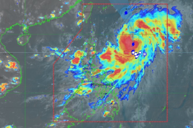
The Philippine Atmospheric, Geophysical and Astronomical Services Administration (Pagasa) on Sunday said Typhoon Julian continues to intensify while remaining almost stationary over the Philippine sea.
In its latest bulletin, Pagasa said Julian was last spotted at 760 kilometers east of Tuguegarao City, Cagayan with maximum sustained winds of 140 kph and gusts of up to 170 kph.
Julian is forecast to gradually accelerate generally northward on Sunday before it will turn north-northwestward or northwestward by Monday.
Tropical Cyclone Wind Signal (TCWS) is unlikely throughout the forecast period and the tropical cyclone will remain far from the landmass.
Light to moderate with at times heavy rains associated with the southwest monsoon will be experienced over Pangasinan, Zambales, and Bataan. The outer rainbands of Julian may bring light to moderate rains over Bicol Region, with at times heavy rains over Catanduanes.
The weather bureau said Julian is forecast to continuously intensify within the next 24 to 48 hours and may reach peak intensity on Monday or Tuesday.
“It is forecast to exit the Philippine Area of Responsibility (PAR) on Monday evening or Tuesday early morning,” Pagasa said. Ella Dionisio/DMS
Latest Videos
- THE UNTOLD STORY EXPERT INSIGHTS INTO THE UKRAINE
- NEGOTIATING A NEW ORDER US RUSSIA TALKS ON UKRAIN
- Ukraine: A Pawn in the Geopolitical Game? Will Trump Intervene?
- US VP VANCE CRITICIZES EUROPEAN DEMOCRACIES AT MUNICH SECURITY CONFERENCE
- UNCOVERING THE WEB OF DECEIT: CIA INFILTRATION OF THE MEDIA
- SHIFTING SANDS: TULSI GABBARD’S CONFIRMATION AND THE EVOLVING GLOBAL LANDSCAPE
- FAUCI SCANDAL: A THREAT TO GLOBAL HEALTH AND DEMOCRACY
![]()
