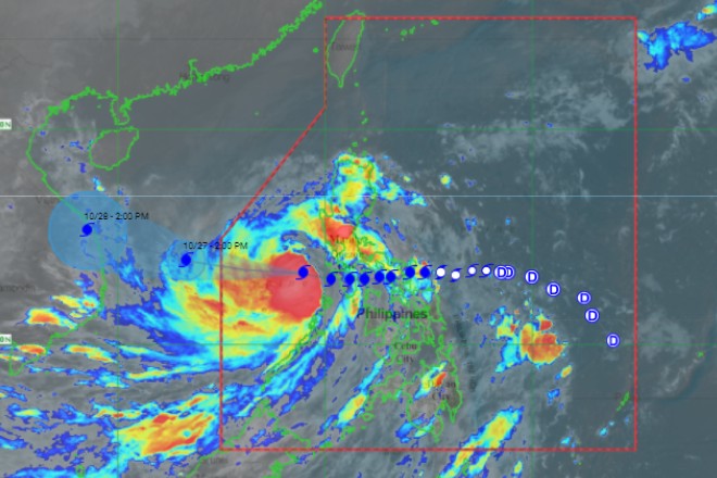
”Quinta” gains strength as it moves to West Philippine Sea
October 26, 2020
Typhoon ''Quinta'' slightly intensified as it moved west-northwestward over the West Philippine Sea and is expected to leave the Philippine Area of Responsibility (PAR) by Tuesday morning, the Philippine Atmospheric, Geophysical, and Astronomical Services Administration (Pagasa) said on Monday.
In its 5pm bulletin, Pagasa said Quinta was located 310 km west of Calapan City, Oriental Mindoro with winds of up to 130 kph and gusts up to 160 kph.
Quinta is moving westward at 25kph.
“Quinta may reach its peak intensity within 24 hours,” Pagasa said.
Only Tropical Cyclone Wind Signal Number One was up as ''Quinta'' is moving away from the country, Pagasa said.
This was raised in Batangas, Occidental Mindoro including Lubang Island, Oriental Mindoro, Calamian Islands, and the extreme northern portion of Antique (Caluya).
The weather bureau said Quinta will bring moderate to heavy with intense rains over Occidental Mindoro, Oriental Mindoro, northern Palawan including Calamian and Cuyo Islands, Calabarzon, Aurora, and Isabela on Monday throughout Tuesday morning.
The tailend of a frontal system will likewise bring moderate to heavy rains over Cagayan, Apayao, Kalinga, Abra, Ilocos Norte, and Ilocos Sur.
Pagasa also said the two weather systems will also bring light to moderate with at times heavy rains over Metro Manila, Western Visayas, Zamboanga Peninsula, Bangsamoro, and the rest of Luzon.
Aside from ''Quinta'', Pagasa is also monitoring a low pressure area located east of Southern Luzon.
“This low pressure area may enter the Philippine Area of Responsibility on Wednesday or Thursday morning but is less likely to develop into tropical depression in the next 48 hours,” it said. Ella Dionisio/DMS
Latest Videos
- THE UNTOLD STORY EXPERT INSIGHTS INTO THE UKRAINE
- NEGOTIATING A NEW ORDER US RUSSIA TALKS ON UKRAIN
- Ukraine: A Pawn in the Geopolitical Game? Will Trump Intervene?
- US VP VANCE CRITICIZES EUROPEAN DEMOCRACIES AT MUNICH SECURITY CONFERENCE
- UNCOVERING THE WEB OF DECEIT: CIA INFILTRATION OF THE MEDIA
- SHIFTING SANDS: TULSI GABBARD’S CONFIRMATION AND THE EVOLVING GLOBAL LANDSCAPE
- FAUCI SCANDAL: A THREAT TO GLOBAL HEALTH AND DEMOCRACY


