


“Ramon” to make landfall in N. Cagayan – Pagasa
November 18, 2019
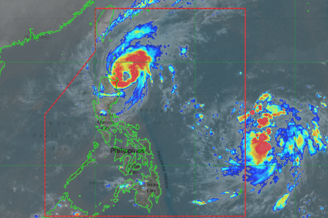
Severe tropical storm "Ramon" has intensified further as it is expected to make a landfall over Northern Cagayan on Monday night or until Tuesday morning, the Philippine Atmospheric, Geophysical and Astronomical Services Administration (Pagasa) said.
In its latest bulletin, Ramon was seen located at 125 kilometer east of Aparri, Cagayan with maximum sustained winds of 100 kilometers per hour (kph) and gusts of up to 125 kph.
It was moving north northwest at 10 kph.
"Ramon is forecast to make landfall over Northern Cagayan between tonight and tomorrow morning,” the weather bureau said.
Tropical Cyclone Wind Signal (TCWS) number two was raised over Cagayan (including Babuyan Islands); northern portion of Isabela (Sta. Maria, San Pablo, Maconacon, Cabagan, Sto. Tomas, Quezon, Delfin Albano, Tumauini, and Divilacan); Apayao; Kalinga; and Ilocos Norte.
TCWS number one was hoisted over Batanes, Ilocos Sur, Abra, Mountain Province, Benguet, Ifugao, La Union, Northern Aurora (Dilasag, Casiguran, and Dinalungan); and the rest of Isabela.
Pagasa said moderate with occasional to frequent heavy rains would be experienced over Cagayan including the Babuyan Islands, Batanes, the northern portion of Isabela, Ilocos Norte and Apayao.
Light to moderate with intermittent heavy rains over the rest of Ilocos Norte, rest of Isabela, Kalinga, Abra, and Ilocos Norte might be experienced Monday night while light to moderate with occasional heavy rains could be felt over Northern Cagayan including Babuyan Islands, Batanes, Apayao, and the northern portion of Ilocos Norte.
Light to moderate with intermittent heavy rains over the rest of Ilocos Norte, Isabela, Kalinga, Abra, Ilocos Sur, and the rest of Cagayan is expected on Tuesday.
Pagasa also advised residents in the aforementioned areas, especially those living in areas identified to be highly or very highly susceptible to flooding and rain-induced landslides, to take appropriate actions, coordinate with local disaster risk reduction and management offices, and continue monitoring for updates.
Ramon is expected to leave the Philippine Area of Responsibility (PAR) by Thursday afternoon.
As of 2pm, Pagasa monitored a low pressure area (LPA) that was expected to enter PAR within 24 hours. Ella Dionisio/DMS
Latest Videos
- THE UNTOLD STORY EXPERT INSIGHTS INTO THE UKRAINE
- NEGOTIATING A NEW ORDER US RUSSIA TALKS ON UKRAIN
- Ukraine: A Pawn in the Geopolitical Game? Will Trump Intervene?
- US VP VANCE CRITICIZES EUROPEAN DEMOCRACIES AT MUNICH SECURITY CONFERENCE
- UNCOVERING THE WEB OF DECEIT: CIA INFILTRATION OF THE MEDIA
- SHIFTING SANDS: TULSI GABBARD’S CONFIRMATION AND THE EVOLVING GLOBAL LANDSCAPE
- FAUCI SCANDAL: A THREAT TO GLOBAL HEALTH AND DEMOCRACY
![]()
