


“Tonyo” to intensify into tropical storm, says Pagasa
November 8, 2020
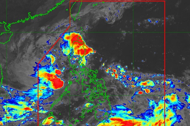
Tropical depression "Tonyo" is expected to intensify into a tropical storm and may exit the Philippine Area of Responsibility (PAR) by Monday morning, according to the Philippine Atmospheric, Geophysical, and Astronomical Services Administration (Pagasa) on Sunday.
Based on its latest bulletin, Pagasa said Tonyo was last spotted at 185 km west of Calapan City, Oriental Mindoro with maximum sustained winds of 45 kph and gusts of up to 55 kph.
The weather bureau said Tonyo is moving south westward at 25 kph and will move westward towards the western boundary of PAR.
“It may exit the PAR tomorrow morning. Tonyo is forecast to intensify into a tropical storm within the next 24 hours,” it added.
The tropical depression made a landfall over Torrijos, Marinduque around 4:30am and San Juan, Batangas around 8am, Sunday.
Pagasa said Tonyo will bring light to moderate with at times heavy rains over Ilocos Region, Cordillera Administrative Region, Cagayan Valley, Aurora, and Palawan including Calamian and Kalayaan Islands.
The Tropical Cyclone Wind Signal (TCWS) #1 over the northwestern portion of Occidental Mindoro is now lifted.
Meanwhile, the Low Pressure Area (LPA) that is also being monitored by Pagasa was last spotted at 920 km East of Hinatuan, Surigao del Sur.
“This disturbance may develop into Tropical Depression 'Ulysses' within 24 to 36 hours and is likely to further intensify,” Pagasa said.
It is forecast to move generally north-northwestward today through Monday evening, then northwestward to west-northwestward towards the Central-Southern Luzon area.
“At the moment, the LPA has no direct effect to any portion of the country. However, as it moves closer to the landmass, it may bring rains over the eastern sections of Luzon and Visayas beginning tomorrow (Monday) afternoon,” Pagasa said. Ella Dionisio/DMS
Latest Videos
- THE UNTOLD STORY EXPERT INSIGHTS INTO THE UKRAINE
- NEGOTIATING A NEW ORDER US RUSSIA TALKS ON UKRAIN
- Ukraine: A Pawn in the Geopolitical Game? Will Trump Intervene?
- US VP VANCE CRITICIZES EUROPEAN DEMOCRACIES AT MUNICH SECURITY CONFERENCE
- UNCOVERING THE WEB OF DECEIT: CIA INFILTRATION OF THE MEDIA
- SHIFTING SANDS: TULSI GABBARD’S CONFIRMATION AND THE EVOLVING GLOBAL LANDSCAPE
- FAUCI SCANDAL: A THREAT TO GLOBAL HEALTH AND DEMOCRACY
![]()
