


Tropical Depression Agaton to make landfall over Caraga late Monday or Tuesday
January 1, 2018
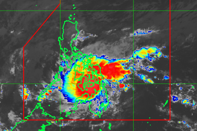
A low pressure area at the eastern side of southern Philippines has developed into a tropical depression around 2 pm.
Philippine Atmospheric Geophysical and Astronomical Services (Pagasa) forecaster Ezra Bulquerin said Monday the lower pressure area has been named Tropical Depression Agaton.
Bulquerin said Agaton is expected to make landfall over the area of Caraga region tonight or until early Tuesday morning and is expected to leave the Philippine area of responsibility by Thursday.
It is the first storm to hit the Philippines and the third in as many weeks.
Captain Armand Balilo, spokesman of the Philippine Coast Guard, said in a text message to the Daily Manila Shimbun said no ship will be allowed to sail in Eastern and Northern Mindanao and areas covered by Agaton.
Balilo said recreational activities in Cagayan de Oro, Siargao and Camiguin have also been suspended.
Agaton is forecast at 65 km east of Dipolog City, Zamboanga del Norte by Tuesday afternoon, then at 80km southeast of Puerto Princesa, Palawan by Wednesday afternoon. It is forecast at 90km east of Pagasa Island, Palawan or outside the Philippine area of responsibility by Thursday afternoon.
As of 5pm, Agaton was last spotted at 175 km east-northeast of Hinatuan, Surigao del Sur with winds of up to 45 kph and gusts of 60kph. It was moving west at 19 kph with a central pressure of 1004 hectopascals.
The state weather bureau raised Tropical Storm Warning Signal Number One over the areas of Southern Leyte, Surigao del Norte including Siargao Island, Surigao del Sur, Dinagat Island, Agusan del Norte, Agusan del Sur, Davao Oriental, Davao del Norte, Davao del Sur, North Cotabato, Compostela Valley, Misamis Oriental, Misamis Occidental, Lanao del Norte, Lanao del Sur, Camiguin and Bukidnon Monday. Robina Asido/DMS
Latest Videos
- THE UNTOLD STORY EXPERT INSIGHTS INTO THE UKRAINE
- NEGOTIATING A NEW ORDER US RUSSIA TALKS ON UKRAIN
- Ukraine: A Pawn in the Geopolitical Game? Will Trump Intervene?
- US VP VANCE CRITICIZES EUROPEAN DEMOCRACIES AT MUNICH SECURITY CONFERENCE
- UNCOVERING THE WEB OF DECEIT: CIA INFILTRATION OF THE MEDIA
- SHIFTING SANDS: TULSI GABBARD’S CONFIRMATION AND THE EVOLVING GLOBAL LANDSCAPE
- FAUCI SCANDAL: A THREAT TO GLOBAL HEALTH AND DEMOCRACY
![]()
