


Tropical Storm Jolina moves toward Aurora, northern provinces
August 25, 2017
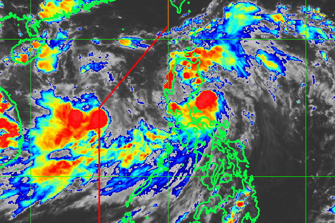
The Philippine Atmospheric, Geophysical and Astronomical Services Administration (PAGASA) on Friday said tropical storm Jolina maintaines its strength as it moves towards Aurora province.
As of 5pm, PAGASA weather forecaster Aldzcar Aurelio said Jolina was last spotted at 110 km south southeast of Casiguran, Aurora with maximum winds of 80 kph and gusts of up to 90 kph.
Jolina is forecast to move west northwest at 19 kph.
Aurelio said the tropical storm is expected to make landfall over Aurora around 6 pm to 9pm Friday .
"After it makes landfall, it will cross Quirino, Nueva Vizcaya, Ifugao, Benguet, Mountain Province, La Union and Ilocos Sur based on our forecast track," he added.
Tropical Cyclone Warning Signal (TCWS) number two was raised over Isabela, Aurora, Quirino, Kalinga, Mountain Province, Ifugao, Ilocos Sur, Benguet, Abra, la Union and Nueva Vizacay.
TCWS number one is up over Cagayan, including the Babuyan Group of Islands, Apayao, Ilocos Norte, Nueva Ecija, Pangasinan, Northern Quezon, including Polillo island, and Camarines Norte.
The weather bureau said areas under signal number two will experience stormy weather while rains with gusty winds may be felt over areas under signal number one.
People living in areas under tropical cyclone warning signals should be alert on possible flashfloods and landslides, Aurelio said.
He added monsoon rains over Metro Manila, the rest of Luzon and Western Visayas may also trigger flashfloods and landslides.
Isolated light to occasionally heavy rains may be experienced over the rest of the country.
The weather bureau also advised the public to cancel any outdoor activities along the coasts of Aurora and Isabela.
Jolina is expected to exit landmass by Saturday morning and leave the Philippine Area of Responsibility by Sunday morning. Ella Dionisio/DMS
Latest Videos
- THE UNTOLD STORY EXPERT INSIGHTS INTO THE UKRAINE
- NEGOTIATING A NEW ORDER US RUSSIA TALKS ON UKRAIN
- Ukraine: A Pawn in the Geopolitical Game? Will Trump Intervene?
- US VP VANCE CRITICIZES EUROPEAN DEMOCRACIES AT MUNICH SECURITY CONFERENCE
- UNCOVERING THE WEB OF DECEIT: CIA INFILTRATION OF THE MEDIA
- SHIFTING SANDS: TULSI GABBARD’S CONFIRMATION AND THE EVOLVING GLOBAL LANDSCAPE
- FAUCI SCANDAL: A THREAT TO GLOBAL HEALTH AND DEMOCRACY
![]()
