


Weather forecasters watching tropical depression, typhoon
September 11, 2017
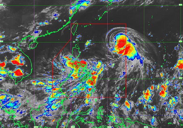
The Philippine Atmospheric, Geophysical and Astronomical Services Administration (PAGASA) on Monday said they were monitoring two weather disturbances inside the country.
PAGASA Administrator Vicente Malano said the low pressure area located over Southern Luzon has developed into a tropical depression and named "Maring" while a new typhoon entered the Philippine Area of Responsibility and given the name "Lannie".
According to the weather bureau, as of 5pm, Maring was spotted at 300 km east of Infanta, Quezon with packing maximum sustained winds of 45 kph and gusts up to 60 kph.
It is forecast to move west northwest at 13 kph.
Maring is expected to make a landfall over Aurora-Quezon area Tuesday afternoon.
Tropical cyclone warning signal number one is raised over Catanduanes, Camarines Norte, Camarines Sur, Northern Quezon including Polillo Island, Aurora, Quirino, and Nueva Ecija.
Moderate to occassionally heavy rains will be experienced over Bicol region, Aurora, Calabarzon, Mimaropa, Metro Manila, bataan, Zambales and Pangasinan.
Visayas and the rest of Luzon will experience light to moderate rains with thunderstorms. Isolated rainshowers are also expected over the Mindanao region.
Malano said Lannie entered PAR around 2pm and is expected to move towards Basco, Batanes going to Taiwan. "Since it's still far, Lannie has still no direct effect in the country," he said.
Lannie was spotted at 1,370 km east of Aparri, Cagayan and has maximum sustained winds of 120 kph, gusts up to 154 kph and 1,004 hectoPascals.
It is forecast to move west northwest at 28 kph.
Both cyclones are expected to leave PAR by Thursday morning if there will be no change in speed and direction. Ella Dionisio/DMS
Latest Videos
- THE UNTOLD STORY EXPERT INSIGHTS INTO THE UKRAINE
- NEGOTIATING A NEW ORDER US RUSSIA TALKS ON UKRAIN
- Ukraine: A Pawn in the Geopolitical Game? Will Trump Intervene?
- US VP VANCE CRITICIZES EUROPEAN DEMOCRACIES AT MUNICH SECURITY CONFERENCE
- UNCOVERING THE WEB OF DECEIT: CIA INFILTRATION OF THE MEDIA
- SHIFTING SANDS: TULSI GABBARD’S CONFIRMATION AND THE EVOLVING GLOBAL LANDSCAPE
- FAUCI SCANDAL: A THREAT TO GLOBAL HEALTH AND DEMOCRACY
![]()
