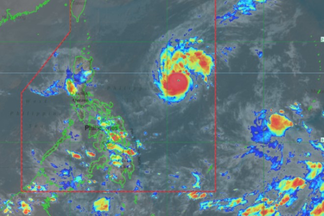
”Rolly” maintains strength as it nears Bicol; Metro Manila under signal number one
October 31, 2020
Tropical Cyclone Warning Signal Number Two was raised by the Philippine Atmospheric Geophysical and Astronomical Services Administration (Pagasa) Saturday morning as Typhoon ''Rolly'' moves closer to Bicol.
As of 5 am, ''Rolly'', with winds of up to 215 km/h and gusts of up to 265 km/h was located 655 kilometers east northeast of Virac, Catanduanes. It was heading west at 20 km/h.
Pagasa kept its Friday night forecast that ''Rolly'' will reach super typhoon category in the next 12 hours.
'''Rolly' is more likely to be near super typhoon strength (185-215 km/h) by the time it grazes Bicol Region and makes landfall over Quezon (Sunday evening)'' said Pagasa.
But after making landfall over Quezon and ''as it traverse over Luzon, Pagasa said 'Rolly' is ''forecast to weaken considerably and emerge as a severe tropical storm or minimal typhoon over the West Philippine Sea.''
Under the new warning signal were Catanduanes, the eastern portion of Camarines Sur and Sorsogon. Winds of greater than 61 km/h and up to 120 km/h may be expected in at least 24 hours in these areas, Pagasa said.
Metro Manila was included in the areas under Tropical Cyclone Warning Signal Number One. The other areas are Camarines Norte, the rest of Camarines Sur, Masbate including Ticao and Burias Islands, Quezon including Polilio Islands, Rizal, Laguna, Cavite, Batangas, Marinduque, Romblon, Occidental Mindoro, Bulacan, Pampanga, Bataan, Zambales, Nueva Ecija, Aurora, Pangasinan, Benguet, Ifugao, Nueva Vizcaya, Quirino, and the southern portion of Isabela,
Also under Tropical Cyclone Warning Signal Number One were Northern Samar, the northern portion of Samar, the eastern portion of Eastern Samar, and the northern portion of Biliran.
Winds of 30-60 km/h or intermittent rains may be expected within 36 hours in these places, Pagasa said. DMS
Latest Videos
- THE UNTOLD STORY EXPERT INSIGHTS INTO THE UKRAINE
- NEGOTIATING A NEW ORDER US RUSSIA TALKS ON UKRAIN
- Ukraine: A Pawn in the Geopolitical Game? Will Trump Intervene?
- US VP VANCE CRITICIZES EUROPEAN DEMOCRACIES AT MUNICH SECURITY CONFERENCE
- UNCOVERING THE WEB OF DECEIT: CIA INFILTRATION OF THE MEDIA
- SHIFTING SANDS: TULSI GABBARD’S CONFIRMATION AND THE EVOLVING GLOBAL LANDSCAPE
- FAUCI SCANDAL: A THREAT TO GLOBAL HEALTH AND DEMOCRACY


