


‘Tisoy’ gathers strength as it moves towards Northern Samar, Albay, Sorsogon
December 3, 2019
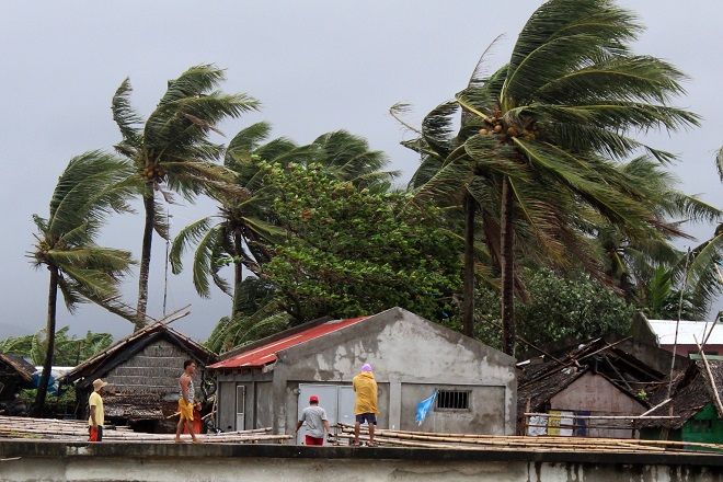
The Philippine Atmospheric, Geophysical and Astronomical Services Administration (Pagasa) said Typhoon 'Tisoy' increased its strength as it moves towards Northern Samar, Albay, and Sorsogon area.
According to the weather bureau's 5 pm bulletin, Tisoy was last located at 195 kilometers east of Juban, Sorsogon. It is heading west at 20 kilometers per hour.
'Tisoy' has maximum winds of up to 150 kilometers per hour and gusts of 185 kilometers per hour.
"The southern eyewall of Typhoon ;Tisoy' is bringing intense rainfall and violent winds over Northern Samar. The eyewall will also hit Sorsogon, Albay, Catanduanes, and Camarines Sur in the next 3 hours," the weather bureau said.
Pagasa said the typhoon is expected to make landfall over Catanduanes, Albay or Sorsogon late Monday or early Tuesday.
Metro Manila, which is part of areas placed under Tropical Cyclone Wind Signal Number 2, will experience intermittent and heavy rain.
Tropical Cyclone Wind Signal Number 3 were raised in several areas all over the country.
Under signal number three are:
Luzon - Catanduanes, Camarines Sur, Albay, Sorsogon, southern portion of Camarines Norte (Daet, San Vicente, San Lorenzo Ruiz, Basud, Mercedes), Masbate including Ticao and Burias Islands, Romblon, and southern portion of Quezon (Mulanay, San Narciso, San Francisco, San Andres).
Visayas - Northern Samar, northern portion of Eastern Samar (Can-avid, Dolores, Maslog, Oras, Arteche, Jipapad, San Policarpio) and northern portion of Samar (Catbalogan, Jiabong, Motiong, Paranas, San Jose de Buan, San Jorge, Pagsanghan, Tarangnan, Sta. Margarita, Gandara, Matuguinao, Calbayog, Tagapul-an, Almagro, Sto. Niño).
The weather bureau said winds of up to 121 kilometers per hour 170 kilometers per hour may be expected in areas under signal number three within the next 18 hours.
Signal number two was raised over the following:
Luzon - Metro Manila, Bulacan, Bataan, Tarlac, Pampanga, Nueva Ecija southern Aurora (Dipaculao, Maria Aurora, Baler, San Luis, Dingalan), Cavite, Batangas, Laguna, Rizal, and the rest of Quezon including Polillo Islands, Oriental Mindoro, Occidental Mindoro, Calamian Islands, Zambales.
Visayas - Rest of Eastern Samar, rest of Samar, Biliran, Aklan, Capiz, Antique, Iloilo, northern portion of Negros Occidental(Talisay, Calatrava, Silay, Enrique B. Magalona, Victorias, Manapla, Cadiz, Sagay, Escalante, Toboso), Northern Cebu (Daanbantayan, Bantayan, Madridejos, Santa Fe, Medellin, Bogo City, San Remigio, Tabogon, Tabuelan, Tuburan, Carmen Borbon, Sogod, Catmon, Asturias and Camotes Islands), northern portion of Leyte ( Baybay, Mahaplag, Abuyog, Javier, Macarthur, Mayorga, La Paz, Dulag, Albuera, Barauen, Julita, Tolosa, Tanauan, Tabontabon, Dagami, Pastrana, Palo, Sta. Fe, Tacloban, Alangalang, Jaro, Babatngon, San Miguel, Barugo, Tunga, Carigara, Capoocan, Leyte, Calubian, San Isidro, Tabango, Villaba, Kananga, Matag-ob, Palompon, Isabel, Merida, Ormoc) and Guimaras.
Winds greater than 61 kilometers per hour to 120 kilometers per hour may hit these areas in at least 24 hours.
Signal number one was raised over:
Luzon - Southern Isabela (Palanan, Dinapigue, San Mariano, San Guillermo, Benito Soliven, Naguilian, Reina Mercedes, Luna, Aurora, Cabatuan, San Mateo, Cauayan City, Alicia, Angadanan, Ramon, San Isidro, Echague, Cordon, Santiago City, Jones and, San Agustin), Mountain Province, Ifugao, Benguet, Nueva Vizcaya, Ilocos Sur, La Union, Pangasinan, Quirino, and rest of Aurora.
Visayas - Rest of Negros Occidental, Metro Cebu (Balamban, Toledo City, Pinamungahan, Aloguinsan, Naga City, Talisay City, Cordova, Minglanilla, Lapu-Lapu City, Mandaue City, Cebu City, Consolacion, Liloan, Compostela, and Danao City), rest of Leyte and Southern Leyte.
Mindanao - Dinagat Islands and Siargao Islands
These areas may experience winds of 30 kilometers per hour to 60 kilometers per hour in at least 36 hours. Tisoy may also cause intermittent rains within the same time period.
"Between tonight and tomorrow morning: Frequent to continuous heavy to intense rains over Bicol Region, Northern Samar, Southern Quezon, Marinduque, and Romblon. Frequent to continuous heavy rains over Samar, Eastern Samar, Rizal, rest of Quezon, Laguna, and Oriental Mindoro. Moderate to intermittent heavy rains over Metro Manila, Occidental Mindoro, rest of Cablaarzon, Cagayan, Isabela, Aurora, and the rest of Eastern Visayas," Pagasa reported
"Between tomorrow morning and evening: Frequent to continuous heavy to intense rains over Calabarzon, Central Luzon, Mindoro provinces, Marinduque, and Romblon. Occasional to frequent heavy rains over Cagayan Valley, Cordillera Administrative Region, and Calamian Islands. Intermittent heavy rains over Aklan ,Capiz, and northern Antique," it added.
Residents in the affected areas are urged to take precautions and were urged to coordinate with local disaster risk reduction and management offices in case of landslides and flooding.
Possible storm surge with height of more than three meters is also forecasted in surge prome areas located at Catanduanes, Camarines Norte, and Camarines Sur. A three-meter storm surge is also expected at coastal areas in Batangas, Quezon, Albay, and Marinduque.
Due to the impending storm surge, the weather bureau announced sea travel is risky over areas under tropical cyclone wind signal. These are the western seaboard of Palawan, central seaboards of Visayas, and the northern and eastern seaboards of Mindanao due to rough sea conditions. Cristina Eloisa Baclig/DMS
Latest Videos
- THE UNTOLD STORY EXPERT INSIGHTS INTO THE UKRAINE
- NEGOTIATING A NEW ORDER US RUSSIA TALKS ON UKRAIN
- Ukraine: A Pawn in the Geopolitical Game? Will Trump Intervene?
- US VP VANCE CRITICIZES EUROPEAN DEMOCRACIES AT MUNICH SECURITY CONFERENCE
- UNCOVERING THE WEB OF DECEIT: CIA INFILTRATION OF THE MEDIA
- SHIFTING SANDS: TULSI GABBARD’S CONFIRMATION AND THE EVOLVING GLOBAL LANDSCAPE
- FAUCI SCANDAL: A THREAT TO GLOBAL HEALTH AND DEMOCRACY
![]()
