


‘Tisoy’ weakening as it moves off Occidental Mindoro
December 3, 2019
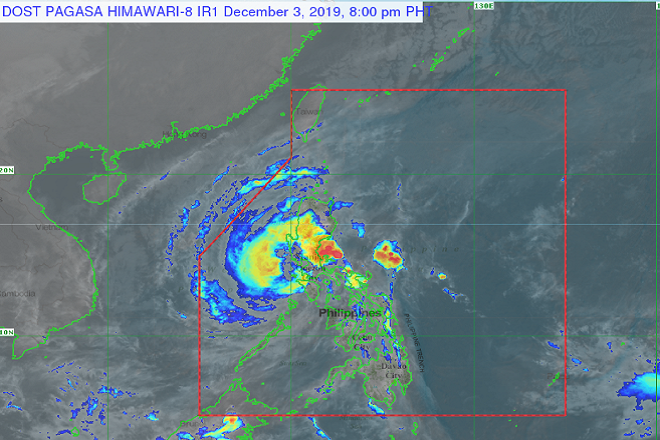
Typhoon 'Tisoy' continued to weaken as it moved off the coast of Occidental Mindoro, the Philippine Atmospheric, Geophysical and Astronomical Services Administration (Pagasa) said Tuesday.
As of 5 pm, 'Tisoy' was located 110 kilometers northwest of San Jose, Occidental Mindoro. It was moving west at 25 kilometers per hour with winds of 130 kilometers per hour and gusts of up to 200 kilometers per hour.
The weather bureau lifted Tropical Cyclone Wind Signal Number 3 in some area. Oriental Mindoro and Occidental Mindoro including Lubang Islang and Batangas are still under signal number 3.
Portions of Luzon still under signal number two include:
Romblon, Camarines Norte, Metro Manila, Bulacan, Bataan, Tarlac, Pampanga, Rizal, Quezon including Polillo Islands, Zambales, Marinduque, Cavite, and Laguna, northern portion of Camarines Sur ( Cabugao, Libmanan, Pamplona, Pasacao, Sipocot, Lupi, Ragay, Del Gallego), southern Nueva Ecija(Cabanatuan City, Cabiao, Gabaldon, Gapan City, General Tinio, Jaen, Laur, Palayan City, Peñaranda, San Antonio, San Isidro, San Leonardo, Santa Rosa, Aliaga, Licab, Zaragoza), southern Aurora (Dipaculao, Maria Aurora, Baler, San Luis Dingalan), and Calamian Islands (Coron, Busuanga, Culion, Linapacan).
Some areas in Luzon and Visayas are under signal number one.
These areas are: the southern portion of Quirino (Nagtipunan), rest of Aurora, northern portion of Palawan (El Nido, Taytay, Araceli, Dumaran), rest of Camarines Sur, Cuyo Islands (Cuyo, Magsaysay, Agutaya), Pangasinan, southern portion of Nueva, Vizcaya(Alfonso Castaneda, Aritao, Dupax Del Norte, Dupax Del Sur, Kasibu, Santa Fe), Burias Island, and rest of Nueva Ecija.
"Between late afternoon today and tomorrow morning: Frequent to continuous heavy (isolated intense rains) over Quezon and Rizal," reported Pagasa.
"Occasional to frequent heavy rains over Mindoro Provinces, Metro Manila, Central Luzon, rest of Cababarzon, Cagayan Valley, Cordillera Administrative Region, Marinduque, and Romblon. Intermittent heavy rains over Calamian Islands," it added.
Possible storm surge with height of more than three meters is also expected over coastal areas in Marinduque, Mindoro Provinces, Romblon, Cavite and Batangas.
Due to the impending storm surge, the weather bureau announced sea travel is risky over areas under tropical cyclone wind signals: the seaboards of Northern Luzon and Visayas, western seaboard of Palawan, and the northern and easter seaboards of Mindanao due to rough seas.
Pagasa forecasts Tisoy to leave the Philippine Area of Responsibility by Thursday morning. Cristina Eloisa Baclig/DMS
Latest Videos
- THE UNTOLD STORY EXPERT INSIGHTS INTO THE UKRAINE
- NEGOTIATING A NEW ORDER US RUSSIA TALKS ON UKRAIN
- Ukraine: A Pawn in the Geopolitical Game? Will Trump Intervene?
- US VP VANCE CRITICIZES EUROPEAN DEMOCRACIES AT MUNICH SECURITY CONFERENCE
- UNCOVERING THE WEB OF DECEIT: CIA INFILTRATION OF THE MEDIA
- SHIFTING SANDS: TULSI GABBARD’S CONFIRMATION AND THE EVOLVING GLOBAL LANDSCAPE
- FAUCI SCANDAL: A THREAT TO GLOBAL HEALTH AND DEMOCRACY
![]()
